سنگ نگاره های طبیعت
برای آشنایی بیشتر با سنگهای قیمتی و فسیل و کانی ها و شهاب سنگها و....سنگ نگاره های طبیعت
برای آشنایی بیشتر با سنگهای قیمتی و فسیل و کانی ها و شهاب سنگها و....ده سنگ قیمتی که از الماس کمیاب ترند
الماس در بین سنگ های قیمتی، یکی از فراوان ترین هاست. ولی سنگ های قیمتی وجود دارد که به مراتب از الماس کمیاب ترند از جمله آن ها می توان به سنگ های قیمتی زیر اشاره کرد:
10- پینیت (Painite)
در سال 2005 کتاب رکوردهای جهانی گینس پینیت را به عنوان کمیاب ترین سنگ قیمتی جهان معرفی کرد. این سنگ نخستین بار در میانمار توسط کانی شناس بریتانیایی آرتور پین در دهه 1950 کشف شد. پینیت امروزه به اندازه گذشته کمیاب نیست و معدن جدیدی از آن در کشور میانمار کشف شده است. اما با این وجود این سنگ هنوز هم یکی از کمیاب ترین سنگ های قیمتی در جهان است.

9- الکساندریت (Alexandrite)
الکساندریت یک جواهر خارق العاده است زیرا در نورهای متفاوت، رنگ های متفاوتی ایجاد می کند. این جواهر در نور آفتاب رنگ سبز-آبی دارد و در نور لامپ های رشته ای به رنگ ارغوانی در می آید. اگر با چرخاندن یک جواهر در دست رنگ های متفاوتی از آن دیده شود به آن جواهر پلئوکروئیک می گویند. الکساندریت به شدت پلئوکروئیک است. الکساندریت از خانواده کریزوبریل است و زمرد هم در همین خانواده قرار می گیرد. خاصیت تغییر رنگ در این سنگ قیمتی و کمیاب بودن این سنگ به دلیل وجود ترکیب نادری از مواد معدنی حاوی تیتانیم، آهن و کروم است.

Agate Basics
This web page contains the following sections:
- What is an Agate?
- How Do Agates Form?
- Agate Characteristics
- How to Search for the Elusive Lake Superior Agate
- Metaphysical Properties of Agates
- Gitche Gumee Geology
WHAT IS AN AGATE?
Agates are semi-precious gemstones that are a variegated form of chalcedony (pronounced kal-sed'-nee), which is silicon dioxide in the form of microscopic fibrous quartz crystals. Agates naturally develop when an empty pocket inside a host rock fills in molecule-by-molecule, layer-by-layer as these microcrystals self organize to form concentric bands or other patterns. The colors and arrangement of the microcrystals are influenced by changes in pressure, temperature, and mineral content that occur during the formation process. Unlike other gemstones, each agate is unique. Even slabs cut from the same specimen will vary in color and design.
HOW DO AGATES FORM?
Agates develop as secondary deposits in hollow cavities, called vesicles. Although they can form in all types of host rock, most of the world's agates developed in ancient volcanic lava. When the continents were first forming, layers of molten lava pushed toward the earth's surface through rift zone cracks, volcanoes, and other geologic events. Within the lava, there were pockets of trapped gases. Later, these gases escaped through cracks that formed as the igneous rock cooled and hardened, leaving hollow cavities. Other cracks and seams also formed when adjoining sections of lava cooled at different rates.
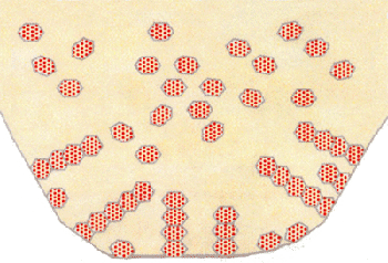
Agate Microcrystal Formation
These empty cavities and seams filled with fluids rich in dissolved and suspended quartz molecules (silica), as well as other mineral impurities. When the silica concentration became supersaturated, it developed a gelatin-like consistency either throughout the pocket or in a layer that served as the active crystallization front. Over time, the silica molecules began to form miniature fibrous microcrystals that attached to the sides of the cavity or seam. During the filling-in process other mineral impurities collected at the inside of the chalcedony silica band, forming intervening and often contrasting bands. This pattern repeated until the entire vesicle was filled in, or until all the silica rich solution was used up. If there was the proper balance of silica and mineral impurities, then the entire cavity filled with alternating bands. If there was an insufficient quantity of mineral impurity or if the pressures and temperatures changed, the cavity completed filling in with macrocrystalline quartz, or another form of silica.
AGATE CHARACTERISTICS
| Physical Properties | ||
| Composition: | SiO2 |  A selection of chalcedony agates. |
| Hardness: | 6.5 to 7 | |
| Specific Gravity: | 2.4 to 2.7 | |
| Refractive Index: | 1.530-1.540 | |
| Fracture: | Conchoidal | |
| Crystal Formation: | Cryptocrystalline | |
| Color: | Varies including gray, blue, yellow, brown, black, white, and green. | |
| Translucency: | Varies from extremely translucent to opaque | |
| Streak: | White | |
| Formation Temperature: | 122 to 572 F (50 to 300 C) | |
| Tests: | Insoluble, unless placed in hydrofluoric acid | |
| Luster: | Waxy | |
| Porous: | Yes | |
| Melting Point: | 1,600 degrees C (2,912 degrees F)91 | |
Types of Agate
There are thousands of named agates found in nearly all countries of the world. Sometimes agates are named because of their formation type, such as a fortification agate. In other cases, they are named after the location in which they are found, such as Brazilian Agate. Sometimes, it is a combination such as a Brazilian Fortification Agate. Below are a few examples.
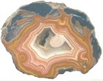
Fortification Agate
This is the most common and distinctive type of agate. In these agates, bands crystallized into concentric layers that more or less follow the shape of the cavity. The banding resembles an aerial view of a fort.
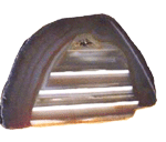
Water-Line Agate (also called water-level or onyx)
During its formation, silica-rich solution either entered the cavity slowly laying one band at a time, excess water drained out leaving a small amount of silica to settle out into separate bands, or the vesicle filled under low pressure. In any case, the silica crystallization in water-level agates is controlled by gravity in one orientation, forming a stack up of parallel bands.

Shadow Agate
Some agates exhibit a shadow effect in which there is what appears to be movement across the agate layers when the specimen is rocked back and forth (or your orientation to the specimen moves). This optical effect only occurs when there are alternating translucent and opaque bands. It is caused when light goes into the agate, but is not reflected out.
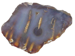
Tube Agate
Tube Agate During the formation of some agates, parallel projections of tiny hair-thin mineral rods grow first within the silica gel, around which later the chalcedony agate micro-crystals form. In some cases the inclusions remain, but sometimes they weather away leaving hollow tubes that subsequently fill in with silica.
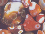
Eye Agates
This mysterious agate characteristic is believed to be formed when most of the silica gel drains from the cavity, leaving only a droplet that “beads up” on the inside wall of the cavity. This droplet crystallizes into solid chalcedony “eyes”. In some cases, crystal growth will continue from this droplet in a manner similar to the formation of stalactites in caves. Later, the pocket fills in with the usual deposition of chalcedony microcrystals.

Plume Agate
These agates initially had formations on their outside layer that formed prior to the deposition of chalcedony bands. They are filament growths of mineral inclusions that resemble ferns or feathers.
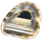
Geode Agate
Geode Agate In some cases the supply of silica-rich water runs out before the entire cavity fills in. When there is a hollow center within a crystalline outer fill, the specimen is considered a geode. Not all geodes have agate banding, but many do. Also, the inner layers can form into several different types of silica mineral crystals and may even have other types of mineral crystals.
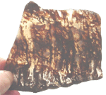
Moss Agate
Moss Agate Moss agates have clusters of mineral inclusions that resemble plants, trees, or landscapes. Most moss agate inclusions are comprised of iron or manganese oxide. In some cases, the inclusions inhibit chalcedony banding allowing the mineral clusters free reign to grow within the silica gel.

Seam Agate
Seam agates for in cracks within host rock, rather than in rounder pockets. The bands form in parallel rows that follow and fill in the crack or seam.
HOW TO SEARCH FOR THE ELUSIVE LAKE SUPERIOR AGATE
Although the information below has been compiled to help those in the upper mid-west to search for Lake Superior agates, the same information is relative to agates in other locations.
Most Lake Superior agates formed in a rift zone approximately 1.2 billion years ago. Rift zones are cracks in the Earth’s surface out of which molten lava flowed. Today, there are still rift zones at the bottom of the Pacific and Atlantic oceans. The rift zone that created Lake Superior agates started in what is now northeast Kansas and continued northeast into what is now the western end of Lake Superior. This hot spot domed up lava several miles high and eventually choked itself off. If it would have continued, it could have split the North American continent in half.
It was in the steam-vacated pockets in this lava that agates formed. Later, as erosion and glaciers broke apart this igneous rock, the forces of nature spread the freed up agates throughout the upper mid-west. The primary area of Lake Superior agate distribution is shown below.
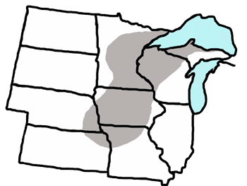
Primary Lake Superior Agate Search Area
The list below provides some basic information to help you find the elusive Lake Superior agate. If you are interested in more detail, please visit the Gitche Gumee Museum and request an agate class, or visit the on-line gift shop to purchase the museum’s book "Understanding and Finding Agates".
- Scan the beach and look for the Iron oxide red color.
- Look for rocks that show evident concentric banding.
- Check for possible entrance and/or escape channels that allowed gases or originally escape from the cavity, silica-rich water to enter, and pressure formed during the agate precipitation process to escape.
- Search for rocks with conchoidal fractures that give the specimen a more angular, irregular shape.
- Look for the pit-marked surface that is either a mold of the rough-textured igneous material of the host rock in which the agate formed, or the pits left from softer minerals that originally lined the cavity but subsequently eroded away.
- Look for any pseudo-bands that exhibit possible structure or banding on the inside of the agate that is not immediately evident on the outside.
- Examine the conchoidal fractures to see if they expose any “windows” to the interior of the rock that indicate that there may be something different on the inside.
- Use the sun or a flashlight to backlight the specimen. Check for translucency as well as any banding that may not be visible without backlighting.
- Scan the rock piles for specimens that have a waxy, gray, chalcedony luster.
- When the angle of sun is low on the horizon, walk toward the sun and look a distance in front of you to look for the extremely translucent red carnelian agates.
- Look for seam agates as well as nodular agates. In both cases, there should be evidence that silica microcrystals precipitated out of solution to fill the agate one molecule and one layer at a time.
- Look for moss agates (growths of mineral inclusions imbedded in a translucent chalcedony).
- Keep a look out for water-line agates with stacked up horizontal layers.
- Be aware of the “agate-want-a-bees”:
- Metamorphic rocks -- Many of these specimens have old sedimentary layers or loose striated patterns of minerals that lined up by density under the intense heat or pressure of metamorphism.
- Chert, Jasper, and Flint -- These chemical first cousins are silica dioxide minerals, but not considered agate. They are always opaque because their microcrystals are granular and packed closer together than the fibrous structure of chalcedony. Like agate, though, can be banded with conchoidal fractures.
- Secondary Fills -- Rocks in which a crack filled in with another mineral all in one shot, like fluid being forced through a soda straw. The seam or crack in the rock could have agatized, but didn’t.
- Fossils -- Some fossils appear to show banding or structure, but instead formed when silica dioxide molecules replaced organic cells. Notice that in some silica fossils, light will shine randomly from the surfaces of larger macro crystals.
METAPHYSICAL PROPERTIES OF AGATE
People for thousands of years have believed that agates have metaphysical properties that enhance life and prevent or help cure all sorts of disorders. Some think that agates provide for balancing your physical, emotional, intellectual, and spiritual energies. Others report that agates stabilize and cleanse your aura and act to smooth dysfunctional energies and transform or eliminate negativity. A partial list of reported agate capabilities is below.
|
|
Return to Top of Menu
GITCHE GUMEE GEOLOGY
Introduction
Geology deals with both the nature and history of the earth. When you study geology, you ask questions such as: How old is the earth? How and where did the materials that compose the earth originate? How did the surface landforms come into being?
Rocks and minerals and the processes that created them are the essence of planet earth, and in understanding them you can better understand us as well as our relationship with the earth. Without geology, many of the things we take for granted would not have been built, assembled, or invented.
Many North American Indians believe that we have a special relationship with planet earth. To them, the earth is family. We have a sacred responsibility to the planet and to all creatures that live upon her. We are all part of the circle, all part of Mother Earth. They believe we are charged with the sacred duty: we are the keepers of the earth. It is this special relationship with planet earth that provides the basis for many of the Native Americans’ beliefs, and much of their culture and science. It is this relationship that also defines their ideas and practices on how to use and manage our natural resources.
In the Beginning – 4.6 billion years ago
Picture the earth’s surface, as it existed in the beginning, pockmarked by impacts by large and small meteorites. No atmosphere or oceans were present. The earth consisted of a random mixture of meteorites accumulated when it formed 4.6 billion years ago. Then, as the earth gradually heated inside from the decay of radioactive elements, the interior reached the melting temperature of the rocks. This ushered in the most spectacular display of volcanic activity in earth’s history, which formed the shields that served as the foundation of today’s continents.
| Precambrian “shields” of the world (in black) with associated stable regions (horizontal rule). These bedrock shields are ancient and complex consisting mainly of igneous and metamorphic rock types. | 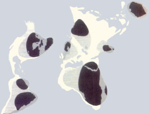 |
Early Precambrian (4.6 to 2.5 billion years ago)
At somewhere around 4 billion years ago we can picture the Lake Superior region as a vast expanse of lifeless ocean with chains of volcanic islands, similar to the present-day Aleutian Islands. Once these islands extended above the surface of the primordial ocean, waves began to beat against the rocks. Since erosion was rapid and the ocean bottom dropped off rather steeply, sediments had little chance to undergo chemical weathering or sorting. This process was repeated over and over again resulting in the formation of thick sequences of monotonously uniform sediments called greywackes.
Most of the mineral wealth in the Lake Superior Basin is found in Precambrian rocks. The deposits include gold, silver, copper, zinc, lead, nickel, cobalt, and iron.
Late Precambrian (Proterozoic)—2.4 billion to 600 million years ago
The Early Proterozoic period lasted 800 million years (2.4 to 1.6 billion years ago). Geologists have concluded that the Lake Superior basin during much of this period was similar to the present day Persian Gulf. The major events of this period included:
- Gradual rifting and break up of a large continent assembled during the early Precambrian period.
- A change to convergent plate motion (plates moving toward each other) wherein one plate was subducted under the other. This caused the development of a volcanic island arc over the subduction zone somewhere offshore from the Superior continent.
- As the plate convergence continued there was then a collision of the island arc with the Superior continent about 1.86 billion years ago. This created the Penokean Mountain range across what is today the Lake Superior basin. This range is comparable to the present day Appalachian Mountains, but probably was as high as the present Rockies. The mountain range extended from northeastern Iowa eastward across Wisconsin, Michigan, and southern Ontario.
- This range was subject to erosion during most of the Middle Proterozoic time. The erosion that erased the Penokean Mountains continued for at least 500 million years, gradually reducing the lofty mountains.
- Next, there was another period of volcanic activity. As lava spilled out of the rift zone, gas bubbles rose slowly through the lava producing tubes. Some of these vesicles later filled in with various substances. The filling of these cavities with silica-rich water, for example, formed Lake Superior agates. The spreading in the rift zone continued for approximately 150 million years. At the conclusion of the rifting period, the Lake Superior region was somewhat like the present east coast of North America.
- Volcanism ended about 1.084 billion years ago and the great pool of basaltic magma began to cool. The weight of the immense pile of lava flows and cooling at the base of the crust resulted in continued subsidence along the rift. Streams flowing into the subsiding basins eroded the volcanic landscape and deposited thousands of feet of red sandstones and conglomerates on alluvial fans. Sands, silts, and mud deposited in lakes that occupied the central part of the rift zone.
Paleozoic Period (600 to 220 million years ago)
The Paleozoic Era contained several different periods including the Cambrian, Ordovician, Silurian, Devonian, Mississippian, Pennsylvanian, and Permian periods.
During the Cambrian period (about 570 million years ago) the North American continent was nearly the size it is now and was mainly above sea level. Then either the continents began to sink or the sea level began to rise, because the seas slowly spread out over the land surface. It took nearly 100 million years for the seas to reach the Lake Superior region. Waves, pounding on the shores of that sea, shifted the particles of sand back and forth along the beach, rounding them to nearly perfect spheres.
These seas were different than all previous seas. For the first time in the geologic record, the seas contained abundant animal and plant life. Skeletons and other remains of these organisms attest to their presence. Fossil remains of these organisms are helpful in reconstructing environments and are invaluable for correlating rock sequences from one area to another. Over the long period of crustal stability and erosion during the last 400 to 500 million years of Precambrian time, the earth’s atmosphere became sufficiently oxygen bearing for animal life to evolve. The fossil record for practically all of Precambrian time indicates that the forms of life on earth were almost entirely plants (algae) and bacteria. Then, in a short period of time at the beginning of the Paleozoic, there was an evolutionary burst of life unlike anything before or since.
The most abundant animals of the Cambrian seas were the trilobites, a type of Crustacean and a biologically complex organism. They were so numerous and diverse that they constituted nearly 60 percent of the varieties of Cambrian life. They ranged in size from less than an inch to more than 20 inches long weighing up to ten pounds. They dominated life in the Cambrian seas for over 100 million years. Like the Cambrian and Ordovician, the Silurian had its own distinctive group of fossils. Also like the Cambrian and Ordovician, nearly all the fossils found in central North America are of animals that flourished in warm tropical seas. It is generally accepted that plate tectonic motions during the Paleozoic period places the Lake Superior region land along the equator.
During the Silurian, corals took over as the dominant species.
During the Devonian, fish developed as the dominant species. (Age of the fishes). Another change during the Devonian was the first evidence of a significant number of land plants. By 360 million years ago, lowland forests with trees up to 30 feet tall were present. While the trees and other plants were different than those of today, they made a profound change in a landscape that had stood naked for over 4 billion years except for probably lichens and algae coatings on the rocks. As hardier varieties of plants evolved, the entire land surface was covered and in the following periods vast swamplands covering much of North America stood for millions of years.
During the Devonian, fish developed as the dominant species. (Age of the fishes). Another change during the Devonian was the first evidence of a significant number of land plants. By 360 million years ago, lowland forests with trees up to 30 feet tall were present. While the trees and other plants were different than those of today, they made a profound change in a landscape that had stood nearly naked for over 4 billion years. Previously, only lichens and algae coated the rocks. As hardier varieties of plants evolved, the entire land surface was covered, including vast swamplands that stood for millions of years. The spreading of plants over the land was followed closely by air-breathing amphibians. With the development of lungs, animals had a vast new array of environments to inhabit. During the next 100 million years, a great variety of land animals evolved, including amphibians, reptiles, and innumerable insects.
With the evolution of land plants and animals the surface of the land changed forever. Plants helped to hold the soil on slopes, retarding erosion, yet decay of plant materials provided various humic acids that promoted chemical weathering of soils.
Mesozoic (220 to 63 million years ago)
During this era, there were three main periods: Triassic, Jurassic, and Cretaceous. This was the era wherein life continued to evolve and explode on earth. Other than significant contributions to the fossil record including the fabulous evolution of dinosaurs, there were not many significant geologic events during this period.
Cenozoic (63 million years ago to present)
The Cenozoic era comprised the Tertiary and Quaternary periods. The only geologically significant event during this era was the Pleistocene Ice Age, which occurred between 2 million and 8,000 years ago. This final chapter of the geologic history of the Lake Superior region was different from all the preceding events. Several times during the Pleistocene, huge masses of glacial ice many thousand feet thick (some geologists estimate up to 10,000 feet) covered most of the northern half of North America. The glaciers scraped and removed most of the weathered rock that had been accumulating north of the Great Lakes since the withdrawal of the Paleozoic seas some 270 million years earlier. Much of this debris was carried southward, and when the ice melted, was deposited in lower Michigan, Illinois, Wisconsin, Iowa, and southern Minnesota. The combination of glacial erosion and deposition greatly altered the landscape filling some valleys, deepening others and in general modifying the previous drainage patterns. The Great Lakes were formed by glacial erosion, as were many other lakes.
| General locations of the boundaries of the Pleistocene ice sheet. | 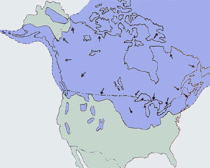 |
When the developing sheets of ice from neighboring valleys met and coalesced with each other, this union formed more extensive areas of ice the gradually deepened, eventually burying the hills on which the ice originally accumulated. During the Pleistocene, as much as 30 percent of the earth’s land surface was covered by glaciers, compared with about 10 percent today. It is estimated that up to 8 percent of all the earth’s water was tied up in glacial ice during the Pleistocene, compared with about 3 percent today. There were two main consequences: (1) It lowered sea level several hundred feet, exposing large areas of the sea floor along the present coastlines; (2) The weight of this ice on the land surface depressed the crust locally as much as 2,000 feet from its normal position.
When the ice reached the Lake Superior region, it was diverted into the major stream valleys, where it advanced as great tongues or lobes. The channeling of ice coupled with the soft underlying bedrock resulted in much erosion in these valleys, deepening them hundreds of feet. Thus, Lake Superior is over 1,300 feet deep and Lake Michigan more than 900 feet deep.
After being weighted down by glaciation, the Upper Peninsula is rebounding between .3 and 6 cm per 100 years. Sault Ste Marie, for example, has rebounded 180 feet in the past 6,000 years.
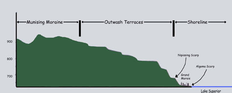
Terrain Detail of Grand Marais
Conclusion
Many Native Americans conceive of time, history, and relationships with the land as a circle, and the circle has come to symbolize a continent-wide philosophy. Every thought and action in Indian life has repercussions in the natural world, and every event in the natural world, every unusual phenomenon has deep significance to human lives. If we show respect for Mother Earth -- she will show respect for us.
The Irokwa Indians of the northeast believe that one must always consider the results of their deeds on the seventh generation after their own. Maybe those of us who are living in the 21st century can learn something from this.
It would be much better and healthier for us, and for planet earth, if we all saw with two eyes instead of one. I believe we should adopt a holistic approach to planet earth. With cooperation, proper perspective, and planet-focused respect, we may preserve our planet on an even keel, develop improved political balance, and keep us humble, respectful, caring, and smiling.
Copyright - 2016 All rights reserved.
Gitche Gumee Museum.
E21739 Brazel Street
Grand Marais, Michigan 49839
http://www.agatelady.com/agate-basics.html
Agate
.What’s the Difference?
If you read about the gem materials used for lapidary work and rock tumbling, you will encounter three names over and over again. These are “agate,” “jasper” and “chalcedony.” These names are often misunderstood and often used incorrectly.
With a little knowledge you can use these names correctly for most specimens. However, some specimens can be difficult or impossible to name correctly with these terms if you must rely only on visual inspection of the material.
We would like to provide a short lesson on these names to help you understand them and use them correctly – as much as that is possible.
What is Chalcedony?
What is microcrystalline quartz? “Quartz” is a mineral composed of silicon and oxygen (SiO2) and the word microcrystalline means that the quartz is in the form of crystals that are smaller than 30 microns in size (a micron is a unit of measure that is 1/1000th of a millimeter). These are very tiny quartz crystals – smaller than can be seen by the unaided eye. (Sometimes the word “cryptocrystalline” is used instead of “microcrystalline.”)
Chalcedony is a very hard material. It has a hardness of 7 on the Mohs scale. It breaks with a conchoidal fracture, and freshly broken pieces have a very smooth, non-granular texture and a waxy to vitreous luster. These characteristics enable chalcedony to be cut and polished into a bright, durable gemstone.
Chalcedony occurs in a wide range of colors. It is often gray, white, brown, red, yellow, orange and black, but it can occur in any color. It can also be banded or have plume, dendritic, mottled, mossy or other color patterns. At one time the word “chalcedony” was reserved in parts of the gemstone industry for a light blue translucent material; however, this use of the word has nearly disappeared.
The Difference Between Agate and Jasper
The primary difference between agate and jasper is in their diaphaneity. The word “diaphaneity” is used to describe “how easily light passes through a material.” There are three general levels of diaphaneity. They are, from highest to lowest:
What is Agate?
Agate is a translucent to semitransparent chalcedony. If you have a piece that is semitransparent you will be able to hold a very thin piece up and see distorted or foggy images through it. If you hold a translucent piece up to a source of light you will see a small amount of light passing through the thin edges. If you hold it up to the light and pass your hand between the material and the source of light, your hand will block the light passing through the material.
Agate is generally a banded material, and observing bands in a specimen of chalcedony is a very good clue that you have an agate. However, some agates do not have obvious bands, or instead of being banded they have plume or mossy inclusions.
How Does Agate Form?
Many agates form in areas of volcanic activity where waters, rich in dissolved silica (SiO2), flow through fractures and cavities in igneous rocks. When the solution is highly concentrated with dissolved silica, a silica gel can form on the walls of these cavities. That gel will slowly crystallize to form microcrystalline quartz.
Over time, additional layers of gel are deposited and these form younger bands of microcrystalline quartz on the walls of the cavity. If the dissolved mineral composition of the silica-rich water changes over time, impurities (elements other than silicon and oxygen) can be incorporated into the gel and into the microcrystalline quartz. These impurities can alter the the color of the microcrystalline quartz. This can produce the color banding, plumes or moss that are often seen in translucent agate.
Although agates typically form in igneous rocks such as basalt, rhyolite, and andesite, they can also form in sedimentary rocks such as limestone. All of these types of rock are more susceptible to weathering than agate. So when the rocks are eventually broken down by weathering, the durable agates will remain. This is why agate nodules are often found in stream valleys that cut through fine-grained igneous rocks or limestone.
What is Jasper?
Jasper is an opaque variety of chalcedony. Neither light nor images pass through.
Microcrystalline quartz in its pure form is semitransparent. When a small amount of impurities or foreign materials are added, the color of the microcrystalline quartz changes and its ability to transmit light decreases. Jasper contains enough impurities and foreign material to render it opaque. So, the real difference between jasper and agate is the amount of impurities and foreign material contained with a specimen.
How Does Jasper Form?
While agate is typically a material that forms in the cavities of an igneous rock or limestone, jasper forms when fine particulate materials are cemented by silica. This often occurs in soft sediments when silica precipitates and cements them into a solid mass. These included particulates are what give jasper its color and opacity. A sedimentary material known as chert forms in extensive bedded deposits, and as an opaque variety of chalcedony it receives the name “jasper.” Jaspers are also known to form when volcanic ash is cemented into a solid material from the precipitation of silica from solution.
Problems With Assigning a Name
If you have a piece of chalcedony, determining if it is an agate or a jasper is easy when that material is clearly semitransparent, translucent or opaque. However, it can be difficult to determine the boundary between translucent and opaque. In addition, some specimens can have translucent zones and opaque zones. What are they called? Some people have solved this problem by using the term “jaspagate” when a specimen contains both jasper and agate.
Assigning a name can be difficult when the composition of the material is unknown. A material known as “Dalmatian stone” has often been called “Dalmatian jasper.” However, we sent some out for analysis and learned that it was not jasper at all, but an igneous rock. The material known as “ocean jasper” is reported to be a rhyolite – another igneous rock.
Happy Tumbling
Source
http://rocktumbler.com/blog/what-is-agate-jasper-chalcedony/
